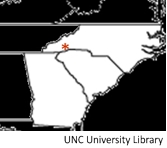
 In this border war which occurred in the first decade of the 1800s, ambiguities in border delineation were again the center of controversy. The strip of land, approximately twelve miles wide, was called the “Orphan Strip”. That strip of land bordered the three states of North Carolina, South Carolina and Georgia.
 Originally, after the Revolutionary War, there was a dispute between North and South Carolina. States who previously had claims to land west of the Appalachian Mountains to the Mississippi River were asked to cede those lands back to the federal government. North Carolina ceded their western land (eventually becoming Tennessee) and South Carolina only needed to cede a small strip of land in order to comply with the federal government’s wishes. Georgia agreed to cede the land that would later become Alabama and Mississippi, and in return the federal government agreed that Georgia would receive the small strip of land that South Carolina had ceded. That occurred in 1802, so now Georgia and North Carolina shared a border.
The problem likely arose because the land was never properly surveyed (duh!). At the eastern edge of the land strip was an area that North Carolina believed to be its Buncombe County. In 1785 settlers had begun to cross the Blue Ridge Mountains and settled that area. By 1802 there were about 800 residents and many of those settlers had received their land grants from South Carolina (remember that officially South Carolina had ceded that strip back to the government who in turn had ceded it to Georgia), while others had received grants from North Carolina.
Of course, agitation and confusion ensued because these settlers didn’t want to lose their land. In 1803, Georgia decided to intervene by proceeding to create Walton County out of the disputed territory, named for one of the signers of the Declaration of Independence, George Walton. Farmers who held South Carolina land grants supported the new county government but rejected any jurisdiction asserted by Buncombe County (North Carolina). Conversely, those who held North Carolina land grants supported Buncombe County but not Walton County (Georgia).
By December 1804 the dispute came to a head when Walton County officials decided to settle the dispute once and for all, seeking to evict any remaining Buncombe County supporters. John Havener, a Buncombe County constable, was struck in the head with the butt of a musket and died. Buncombe County immediately called for militia to be dispatched to the area. On the 19th of December, Major James Brittain with a group of seventy-two militia marched into the area and was joined by twenty-four other North Carolinians who lived in the area.
Ten suspected Walton County officials were captured and sent to Morganton, North Carolina to stand trial for the murder of Havener. The dispute continued until in 1807 a commission was formed in order to settle the matter. After surveying the area properly, the true boundary was found to be a few miles south of its original presumed position. Georgia commissioners finally admitted that all of Walton County rightly belonged to North Carolina.
In the end, all was forgiven (with the exception of the ten men accused of murder – however, those men escaped and were never seen again). North Carolina eventually recognized the South Carolina land grants.
I ran across one person’s story about her genealogical research in which this dispute actually caused some confusion (this might solve someone else’s confusion as well):
For many years I was puzzled by the fact that so many of my ancestors seemed to move around so much, back and forth between North Carolina, South Carolina and Georgia. Moving would have caused tremendous work, time and hardship back then due to the mountainous, inaccessible terrain. There was also so much conflicting information on various census: on one census a person would state that her mother was born in Georgia and on the next census state North Carolina or South Carolina. Then I remembered the Walton War and what confusion it must have caused the inhabitants of this area. For many several years they were claimed as citizens of three different states. I wondered if perhaps they might never have moved at all but were unsure of which state they were being claimed by at the moment. These people could have stayed where they were and yet have technically lived in North Carolina, South Carolina and Georgia during this time period. This was verified by finding some of my ancestors listed on the census of Walton County, Georgia when I know for sure that they were living on land located near the Jackson-Transylvania County, North Carolina border. So if you are working on your genealogy and have relatives in this area, remember the Walton War! – Shawna Hall (no relation that I know of).
Today, the originally disputed land is now part of the North Carolina county of Transylvania.
 Did you enjoy this article? Yes? Check out Digging History Magazine. Since January 2018 new articles are published in a digital magazine (PDF) available by individual issue purchase or subscription (with three options). Most issues run between 70-85 pages, filled with articles of interest to history-lovers and genealogists — it’s all history, right? 🙂 No ads — just carefully-researched, well-written stories, complete with footnotes and sources.
Want to know more or try out a free issue? You can download either (or both) of the January-February 2019 and March-April 2019 issues here: https://digging-history.com/free-samples/
Thanks for stopping by!